Below is the 1987 City Consulting Engineer of Belfast A. Neil Finlayson, P.E. findings to Wilma Moses, Belfast City Manager. Mr.Gerry is at 18 Seaview Terrace across the street from me (now owned by Charles Beck) Mrs. McDonald is at 11 Seaview Terrace next door to me (now owned by Rose and Frank Costello) and Dr. Caswell is 17 Seaview Terrace (now owned by me, Laurie Allen) A Bermuda I mean Belfast triangle.
August 26, 1987
Subject: Seaview Terrace Drainage Problems
Dear Wilma:
The rain water drainage problems which we investigated this morning on Seaview Terrace, are primarily due to the overall topography of the land on which this development was built. In general, the land slopes downward from South to North across Seaview Terrace. In addition, there is a slope form the direction of Route 1 Bypass downwards towards Northport Ave.
The owner complaints, as I recall them, are as follows:
1. Mr.Gerry states that after heavy rains his basement tends to collect water. (The same problem of basement flooding is a regular feature in many other houses in Belfast.)
This problem could be minimized by having Keith Pooler lower the culvert that crosses the road at Mr. Gerry's lot and make sure it is clean inside for maximum water flow from his lot across Seaview Terrace to the boundary between Mrs. McDonald's lot and Dr. Caswell's. In addition, it should be suggested to Mr. Gerry that if he would increase the cross sectional area of his ditch which empties into the City culvert, (now about 6" wide and of equal depth), there would be less tendency for water to collect on his lawn, and thus send its way into his basement.
2. Mrs. McDonald says that rain water drainage, after a heavy rain, can rise to the point where it gets into and damage expensive plantings at the eastern side of her house. In part, this may be due to water flooding across the road from Mr. Gerry's house. But there is also water coming down on her side of the road from other lots above hers. Lowering and cleaning the culvert in front of Mr.Gerry's house would tend to minimize flooding over the road, but the overall effect with respect to correcting her problem might well be negligible.
It should be suggested to Mrs. McDonald that if she had a sizeable ditch dug from the end of the culvert on her side of the road and carried it back to the "Brook", it would probably reduce the flooding of her gardens.
3. Dr. Caswell has mentioned that after heavy rains the brook can flood and create problems for all owners whose lots back up to it. He suggests that the City clean it out to reduce this tendency. I have a feeling that this brook is NOTHING MORE THAN A DRAINAGE DITCH PUT IN BY THE DEVELOPER OF THE TRACT.
You could suggest to Dr. Caswell that his brook is private property and that if he, and other owners, feel strongly about the problem, that the hire a contractor to clean out the brook to their specifications.
Summary:
As you mentioned during our visit, the basic cause of the flooding is the topography of the land which the owners bought.
Actions:
Suggest to the owners:
1. Aside from the culvert, which is on a Belfast City street and thus a City responsibility, all other possible corrective actions involve private land and must be carried out by the owners themselves.
2. The flooding problems that exist are inherent in the topography of the land that them bought; it has existed pretty much as it is now, from the outset. The problems are not due to any action by the City and are therefore not a direct City responsibility. However, in accordance with your belief that the City should assist the residents with their problems, I have added my thoughts on the action the might take to minimize these problems.
Very Truly Yours,
A. Neil Finlayson, P.E.
City of Belfast Consulting Engineer
1939 - QUAD 40- To the right of the red 40 is the farmhouse still standing on the now corner of Northport
Ave and Seaview Terrace. THERE IS NO STREAM! This lot is cleared and clear visibility of NO
STREAM.
CASE CLOSED- MORE MAPS BELOW TO SHOW FORCED SLAUGHTER. City Planner, Wayne Marshall
has a slew of maps locked in his den. He was forced to show me maps having said he had them- these
are the one's he chose and sent down to the City Manager. I don't think he counted on me having a
camera this time. Surely, he has more damning maps. I have pictures of others- but I think these are the closest to where Seaview Terrace would be.
They know all this, their resolution is to eradicate me. Kick and kick this mom that won't fall victim to their corruption. Kick away- it is your shame. My badge is truth. If they had a map showing a stream once ran through Seaview Terrace, don't we know they'd be blowing that map up to the size of their greedy cruel ego's and draping it though out Belfast for all to see and to truly end this disgusting abuse. Then, I'd focus on the ethics to take a private property stream and the calculated forcing of slaughter with out easements, right of ways, compensations- SEWERS! Anyway you look at this, they are all deviated sick. They have forced us to hell and pending demise, when we had barely escaped to begin again.

Trying to figure out where this is- Congress St? No stream in this area.

 |
1963? New Rte 1 Congress St intersecting. Wight St to right. Seaview Terrace to be would be in bottom left on the right
side of Rte 1. Looking at the 1939 map where there is a visible stream that was up by Congress St. running through this
new Rte 1 to Little River. This is where they decided to run a ditch through the future Seaview Terrace to take the runoff
from the new highway. Who owned that parcel then? Compensated? and sold it off to Wendell Mcleod. Belfast gave
approval to make a subdivision in 1966- right there, that runoff ditch needed to be rerouted to City property. Instead, the
beginning of calculated City planning slaughter to tax paying residents.
The City has been using it for all developed runoff, for miles outside of Seaview Terrace- see my hand drawn map below.
City Hall has denied, lied, with held, got caught, lied more, slaughter the flood plain, flood zone private property of 12
families Seaview Terrace. Since 1967. Calculated slaughter by forced water is extermination and probable
drowning/death/murder.
|
 |
| The development of Seaview Terrace. The man made ditch had to be pushed back. For kicks and giggles- say it was stream- moving it makes it not natural. This map and below plans were with held from me. I requested these in May 2011. Not given, I did not even know they existed. Then I stormed City Hall unannounced in November 2011 and found the Belfast City Tax Assessor, Bob Whitely looking at this very plans. I was floored- he was floored that I had never been shown them. Later he would tell me, when City Manager Joe Slocum had found out that he let me look at these maps, he flipped. Bob said he never saw that side of Joe before. |

 |
| New Seaview Terrace- and the moved ditch. |
 |
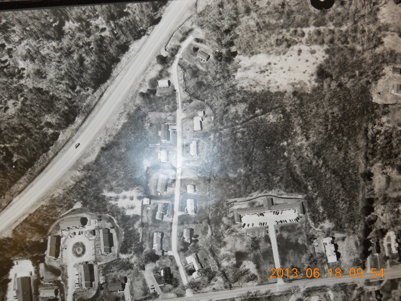
| The green is the forced water into the ditch on Seaview Terrace. The pink is my house/ To the right of Seaview Terrace is Rte 1 North and South- about a mile long here. Red circles are all culverts forcing water to Seaview Terrace, even from across Rte 1. and as far away as Captain Albert Stevens School and The Much on Lincolnville Ave- 2? miles away. There are even more culverts- Congress St has something like 19 culverts sending it down to private property. Sick bastards. |
No comments:
Post a Comment